

Published October 12, 2026 03:37 PM
The crisp air and early October snow dusting several Rocky Mountain resorts are igniting a palpable excitement for the upcoming winter. While ski lifts remain dormant for now, the scientific community and outdoor enthusiasts alike are closely monitoring a powerful meteorological force that promises to shape the season: an exceptionally strong El Niño event, potentially the most potent on record. Climate models, which have been tracking this phenomenon for months, indicate a high probability of a "super" El Niño, with significant implications for precipitation and temperature patterns across North America.
The Science Behind the Super El Niño
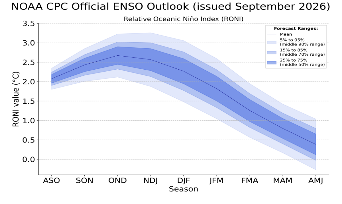
El Niño, a climate pattern characterized by unusually warm surface waters in the central and eastern tropical Pacific Ocean, exerts a profound influence on global weather systems. This year’s iteration is particularly noteworthy. The National Oceanic and Atmospheric Administration (NOAA) and its Climate Prediction Center (CPC) have issued stark assessments, projecting a 100 percent chance of El Niño conditions persisting through at least the January to March period. More critically, the likelihood of this event being "very strong" stands at over 90 percent. The CPC further estimates a 75 percent chance that this El Niño will surpass the strength of any recorded since 1950, placing it in unprecedented territory.
The genesis of this robust El Niño can be traced to a sustained period of elevated sea surface temperatures across the Pacific. This warmth fuels increased atmospheric convection, a process where warm, moist air rises. As observed in the recent past, this enhanced convection has already manifested in extreme weather events, such as the massive flash floods that inundated the Grand Canyon and other parts of the desert Southwest in September. The remnants of Hurricane Polo, itself a product of Pacific warmth, also delivered much-needed rainfall to arid New Mexico shortly thereafter.
Forecasting the Winter: Factors Favoring Snowfall
The sheer magnitude of the 2026 El Niño introduces an element of the unknown, as scientists are venturing into largely uncharted atmospheric territory. However, the prevailing optimistic outlook for winter snowfall, particularly in the western United States, is grounded in the understanding of how such powerful El Niño events typically interact with the North American climate.
A key factor is the increased moisture-carrying capacity of warmer air. This phenomenon suggests the potential for "supercharged" winter storms, including atmospheric rivers, which can deliver significant precipitation. Resorts situated at higher altitudes, particularly in Utah and Colorado, are well-positioned to benefit from these moisture-laden systems, as elevation often ensures snowfall even when warmer air masses are present.
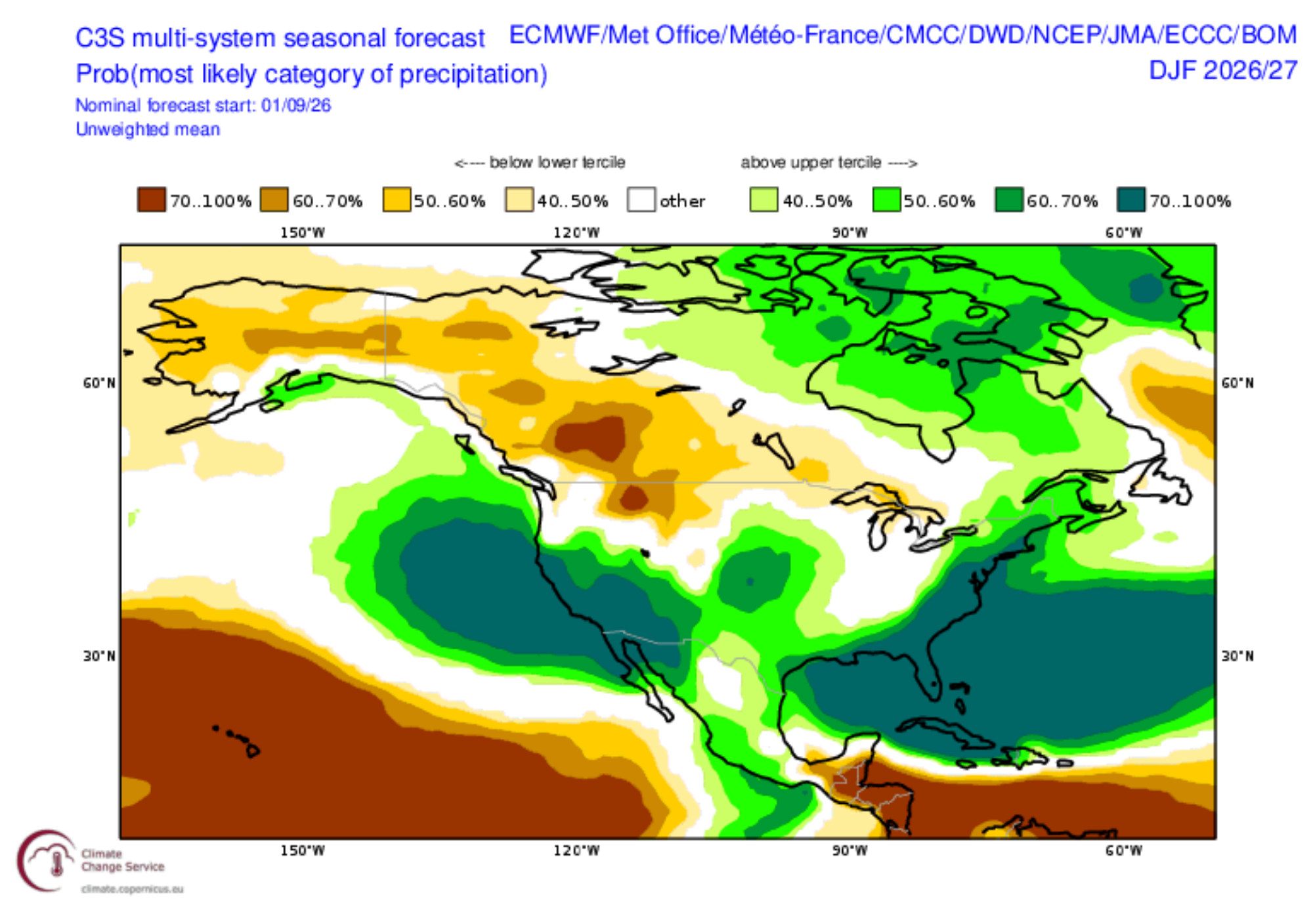
The Copernicus Climate Change Service (C3S), the European Union’s equivalent to the CPC, provides a global perspective on seasonal outlooks. Their ensemble modeling, which integrates data from multiple global climate models, also points towards above-average precipitation for much of the U.S. during the mid-winter months. Notably, the C3S outlook shows increased confidence in precipitation forecasts for the southwestern and eastern United States, even when accounting for varying levels of model certainty.
Regional Outlook: Where to Aim Your Skis
While California often garners attention for its potential to receive atmospheric rivers during El Niño events, the state also faces a higher susceptibility to rain, especially during warmer winters. Consequently, landlocked, continental states like Utah and Colorado are generally considered more insulated from the direct impact of warm maritime air. Mammoth Mountain in California, with its significant elevation, may still see snow while lower-lying resorts in the state experience rain.
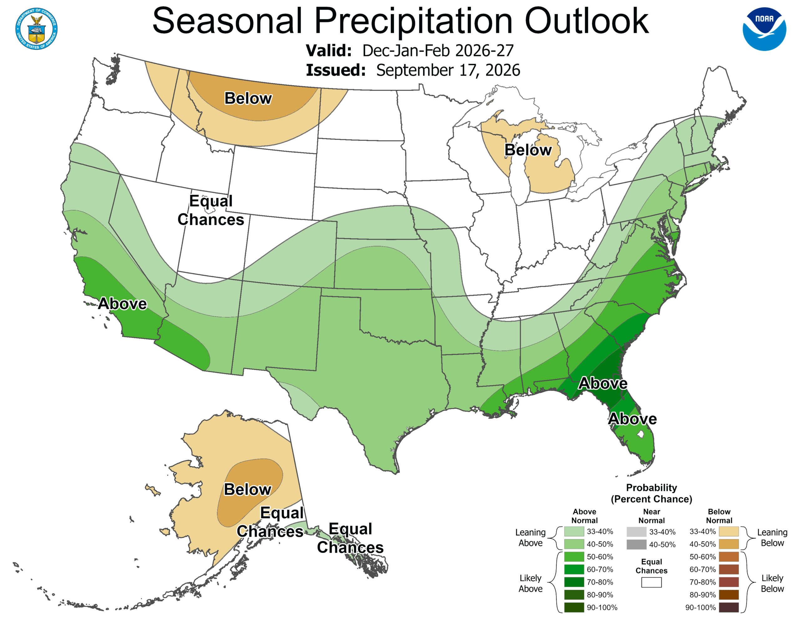
Arizona and New Mexico are also predicted to benefit from increased precipitation. However, the ski infrastructure in these states is less developed compared to traditional winter sports hubs. Taos Ski Valley remains the sole resort in these states offering over 1,000 skiable acres, though numerous smaller, local ski hills contribute to the region’s charm.
Conversely, forecasts for Canada suggest a below-average winter. The farther north one looks, the greater the confidence in reduced precipitation. This presents a challenge for the approximately 20 million Canadian skier visits annually. However, Canada’s northern latitude means that even a less-than-ideal season can still deliver cold, powdery conditions. If temperature, rather than precipitation, becomes the limiting factor, Canadian resorts might still offer a favorable experience. This sentiment extends to the entire northern tier of the United States, where a "below-average" winter is anticipated. Resorts in these regions, such as Whistler, Revelstoke, Big Sky, Whitewater, and Mt. Baker, are renowned for their significant snowfall. Even a below-average season in these locations could still yield more total snow than many areas expecting above-average precipitation.
The New England Enigma
New England represents a more uncertain variable in the winter forecast. Models indicate an increased likelihood of precipitation in the region, which is consistent with typical El Niño patterns where storms tracking up the southeastern U.S. coast can bring rain and snow to the Northeast. However, a significant caveat for New England resorts is their limited altitude buffer. If incoming storms draw moisture from the Gulf and Atlantic without sufficient cold air, they can result in rain extending deep into the mountainous terrain. The presence of cold air is often dictated by more volatile atmospheric features like the Arctic Oscillation (AO), which are notoriously difficult to predict beyond a few weeks.
Understanding El Niño’s Influence on North American Weather
The recurring question is how warm waters in the equatorial Pacific can so dramatically alter precipitation patterns across North America. The answer lies in the Hadley circulation, a global atmospheric system that transports heat and moisture from the tropics towards the poles. Normally, heat rises in the tropics, spreads poleward at high altitudes, sinks around 30 degrees latitude, and then returns to the equator via trade winds.
During an El Niño event, the exceptionally warm waters in the central and eastern Pacific intensify this circulation. The enhanced convection leads to a strengthening and southward shift of the subtropical jet stream, particularly along the Pacific coast. This redirection of the jet stream is the primary mechanism responsible for increased storminess in the southern tier of the United States and drier conditions in the north.
The Hype and the Reality of Seasonal Forecasting
The prospect of a blockbuster winter has generated considerable excitement, particularly for California. While the state has a strong chance of experiencing an El Niño-fueled winter, the author of the original report expresses a more cautious overall outlook for North America. This caution stems from the inherent limitations of seasonal forecasts. These projections offer valuable clues but are not definitive answers. The occurrence of just one or two significant storms can dramatically alter a region’s precipitation totals for an entire season. Furthermore, shorter-term weather phenomena like the AO and the Madden-Julian Oscillation (MJO), which are not predictable months in advance, play a crucial role in shaping weather patterns.
Despite these limitations, the advancements in climate modeling and computational power have made long-term forecasting increasingly sophisticated. The accuracy of these models was demonstrated in the forecast for the Southern Hemisphere’s winter season of 2026. Projections accurately highlighted an above-average snowfall for the northernmost resorts in South America, while also warning of potential weather-related closures. This materialized with Portillo experiencing road closures for 34 consecutive days due to a series of storms. Conversely, Australia’s winter was accurately predicted to be poor, with warm temperatures, rather than a lack of precipitation, being the primary detractor, aligning with model signals for both warmth and dryness. New Zealand’s season also trended favorably toward the Southern Lakes, in line with forecasts.
Factors Working Against a Snowy Winter
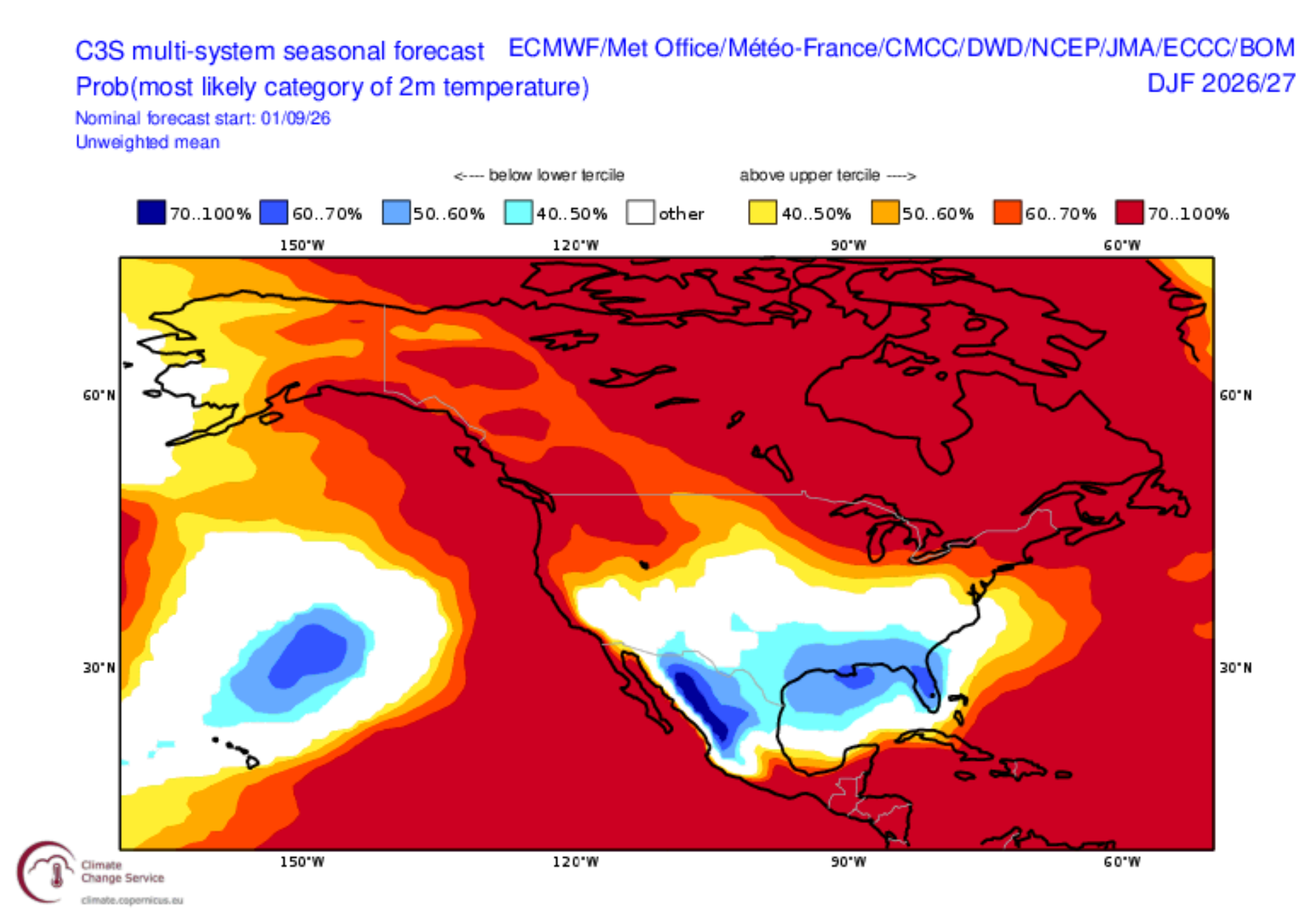
The most significant factor posing a challenge to a robust winter season is persistent warmth. Despite the presence of monsoonal moisture, temperatures have remained elevated. Following a record-warm 2025-2026 winter, the summer of 2026 also experienced record-breaking temperatures, indicating a sustained warming trend that could impede snowfall at lower elevations and potentially impact snowpack accumulation. This ongoing warmth is a critical counterpoint to the optimistic precipitation forecasts.
The interplay of these factors – the powerful El Niño promising moisture, but persistent warmth threatening to turn snow into rain – creates a complex and dynamic outlook for the upcoming winter. Skiers and snowboarders across North America will be watching the skies with anticipation, hoping for the best while acknowledging the inherent uncertainties of long-range weather forecasting.
