

The arrival of August signals the annual anticipation for winter weather predictions, and the venerable Farmers’ Almanac has once again delivered its highly-anticipated outlook for the 2026-2027 season. Published on August 10, 2026, this year’s forecast, derived from a methodology steeped in two centuries of tradition, paints a picture of stark regional contrasts across the United States and Canada, heavily influenced by the anticipated persistence of an El Niño pattern. While long-range forecasts inherently carry a degree of uncertainty, the Almanac’s predictions offer compelling insights for winter sports enthusiasts, agricultural planners, and municipal services preparing for the months ahead.
A Legacy of Long-Range Forecasting: The Farmers’ Almanac Methodology
For over 200 years, the Farmers’ Almanac has been a cornerstone of American folklore and meteorological prognostication, offering long-range weather predictions that blend astronomical calculations, sunspot activity, tidal action, and various other natural phenomena. Its unique formula, a closely guarded secret passed down through generations of editors, stands apart from modern computer-modeling systems utilized by governmental agencies. Despite its unconventional approach in an era dominated by advanced satellite technology and supercomputers, the Almanac has cultivated a loyal following and often generates significant discussion among meteorologists and the public alike. Its 2026-2027 winter outlook continues this tradition, providing a broad, regional perspective on temperature and precipitation trends rather than precise daily forecasts for specific locations.
El Niño’s Dominant Hand: A Global Climate Driver
Central to the Farmers’ Almanac’s 2026-2027 winter forecast is the expected continuation of El Niño, a climate phenomenon characterized by the warming of sea surface temperatures in the central and eastern tropical Pacific Ocean. El Niño significantly alters global atmospheric circulation patterns, including the position and strength of the jet stream, which in turn influences weather across North America. Typically, a strong El Niño pattern leads to a more active storm track across the southern United States, often resulting in wetter-than-normal conditions. Conversely, it can sometimes contribute to warmer and drier conditions in parts of the northern U.S. and Canada, though regional variations are complex and can be modulated by other climate oscillations.
The Almanac’s alignment with NOAA’s extended outlooks regarding El Niño’s influence underscores the broad consensus among meteorologists that this phenomenon will be a primary driver of winter weather. The expected storm track, extending from Southern California and the Desert Southwest through Texas, the Gulf Coast, and the Southeast, is a classic signature of an El Niño winter. This pattern suggests that much of the southern tier of the United States could experience significantly wetter conditions, impacting everything from water resources to transportation and agriculture.
Regional Outlook: A Mosaic of Winter Experiences
The Farmers’ Almanac’s detailed regional breakdown reveals a winter season that promises diverse conditions, offering both opportunities and challenges across North America.
The Southern Rockies: Prospects for Powder
For ski resorts nestled in the Southern Rockies, particularly in southern Colorado and New Mexico, the forecast offers a reason for cautious optimism. The anticipated active southern storm track, combined with periods of colder air, could translate into frequent opportunities for snowfall in the high elevations. Areas like Taos Ski Valley, Wolf Creek Ski Area, and Arizona Snowbowl are likely to be closely monitoring these developments. Historically, strong El Niño winters have often delivered significant snow totals to these regions, providing a crucial boost to snowpack levels.
However, the forecast also carries a nuance: "nonstop powder" is not guaranteed. The same storm systems bringing moisture to the region could also produce rain, sleet, or wet snow at lower elevations, especially when temperatures hover near the freezing mark. This variability means that while the overall pattern may be favorable, the quality and type of precipitation will be highly dependent on individual storm dynamics and local topography. For skiers, the key takeaway is that the Southern Rockies could present excellent conditions during active periods, making them a prime destination for those willing to chase storms. This influx of snow could also significantly bolster water reserves for states that rely heavily on mountain snowmelt.
The West and Pacific Northwest: A Season of Variability
As one moves northward along the Western Seaboard, the forecast becomes less definitive, suggesting a winter of greater variability. Across much of the interior West, including regions encompassing popular resorts in Utah, Wyoming, and Montana, the Almanac predicts near-normal temperatures. This will be punctuated by fast-moving storms, brief cold snaps, and short-lived snowy periods, often interrupted by milder stretches. This "feast or famine" pattern could prove challenging for resorts relying on sustained snow depths, necessitating efficient snowmaking operations during colder windows. Skiers in areas like Park City, Jackson Hole, and Big Sky might experience periods of excellent conditions interspersed with lulls, requiring flexibility and vigilance in planning trips.
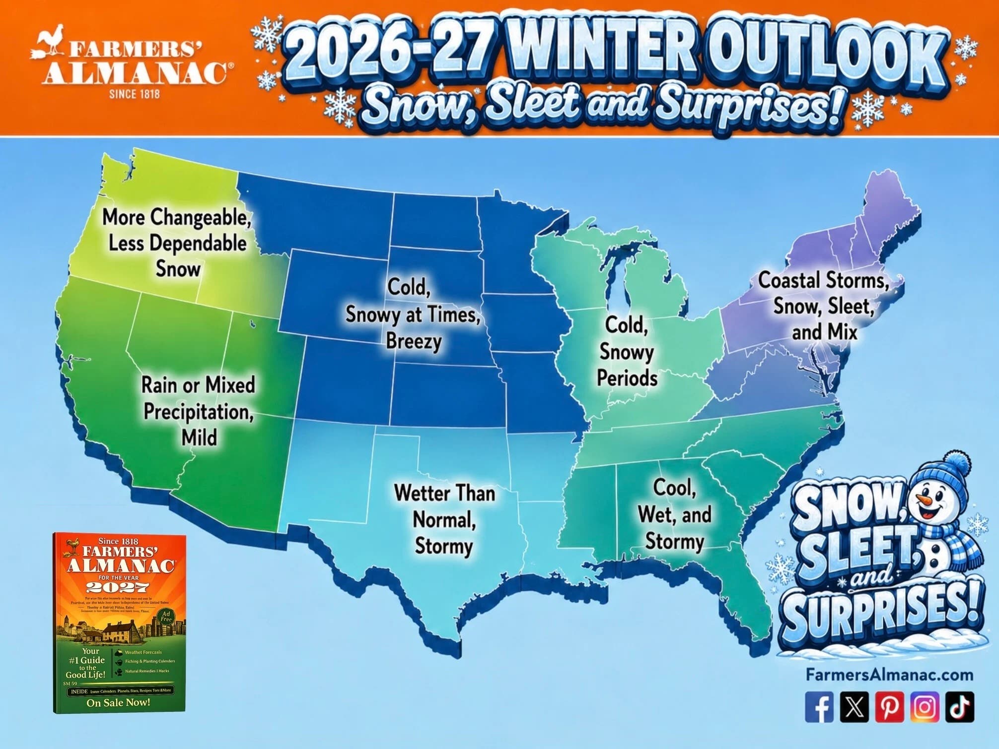
The Pacific Northwest faces an even less encouraging outlook. The Almanac describes the region’s snow season as "more changeable and somewhat less dependable." This implies that Washington, Oregon, Idaho, and British Columbia skiers may contend with greater variability than desired, including more rain-snow line fluctuations and potential for drier periods. Resorts such as Whistler Blackcomb, Mount Baker, and Crystal Mountain, renowned for their deep maritime snowpacks, could see their traditional patterns disrupted. However, meteorologists often highlight the unpredictable nature of atmospheric rivers – powerful, narrow corridors of moisture that can deliver immense amounts of precipitation in a short time. A single, well-timed atmospheric river event could significantly alter the snow fortunes of the Cascades and Coast Ranges, transforming a potentially lean season into a bountiful one. Therefore, while the broad pattern is not screaming "lock in your powder week in the Northwest," local conditions could still surprise.
Northern Rockies and Midwest: A Rollercoaster of Winter Weather
Further east, the forecast for the Northern Plains, Upper Midwest, and Great Lakes calls for a true rollercoaster ride of winter weather. Frequent swings between thawing and freezing, sudden snow squalls, strong winds, and bursts of bitter cold are anticipated. This aligns with El Niño’s typical tendency to push colder, arctic air masses further north, while allowing milder Pacific air to intrude periodically.
For skiers and winter sports enthusiasts in states like Minnesota, Wisconsin, and Michigan, this could translate into a familiar yet frustrating cycle: a significant snowstorm followed by a sharp drop in temperatures, leading to excellent conditions, only to be undone by a subsequent mild spell that melts away some of the gains. Resorts in these regions, such as Boyne Mountain or Lutsen Mountains, are accustomed to such variability and often rely heavily on snowmaking capabilities. The good news is that "near-normal temperatures" do not equate to a snowless winter; the Almanac predicts plenty of short-lived winter weather events. The challenge will be the episodic nature of these events, requiring skiers to be nimble and ready to "pounce" on favorable conditions. This pattern also poses challenges for infrastructure and transportation, with rapid changes in road conditions expected.
The Northeast: A Messy Mix with High Stakes
Perhaps the most complicated outlook belongs to the Northeast. The Farmers’ Almanac anticipates inland parts of the region to experience "several rounds of heavy, wet snow," particularly in January and February. This could be fantastic news for ski areas in Vermont, New Hampshire, and Maine, promising substantial accumulation. Resorts like Killington, Jay Peak, and Sugarloaf could see significant powder days.
However, this promising forecast comes with a considerable asterisk: temperatures are expected to hover precariously close to freezing. This critical detail means that a minor shift in storm track or temperature could dramatically alter the outcome, transforming potential powder into freezing rain, sleet, or even liquid rain. The difference between a memorable powder day and a frustrating washout could be just a few degrees. For the Northeast, this means the winter could be highly variable, with pockets of exceptionally good skiing interspersed with challenging, marginal conditions. Resort operators will need to be exceptionally agile, ready to capitalize on cold snaps for snowmaking and grooming, and manage customer expectations during warmer spells. The potential for ice storms also presents significant risks to power infrastructure and travel.
Broader Implications Beyond the Slopes
The Farmers’ Almanac’s forecast extends beyond the interests of skiers and snowboarders, carrying broader implications for various sectors. For agriculture, particularly in the southern states, a wetter-than-normal winter could be beneficial for replenishing soil moisture and water tables, crucial for upcoming planting seasons. However, excessive rainfall could also lead to localized flooding and impede field work.
Municipalities across all regions will need to prepare for the specific challenges outlined: heavy snow and ice in the Northeast, potential flooding in the South, and rapid freeze-thaw cycles in the Midwest. Transportation departments will face increased demands for snow removal and de-icing operations. Energy providers will need to brace for potential surges in demand during cold snaps and be prepared for power outages due to ice storms or heavy snow. The economic impact on winter tourism, both positive in areas predicted to receive good snow and potentially negative in areas with high variability, will also be closely watched.
The Inherent Uncertainty of Long-Range Predictions
It is crucial to approach any long-range forecast, including that of the Farmers’ Almanac, with a healthy degree of caution. While the Almanac boasts a long history, and modern meteorology is constantly advancing, forecasting weather months in advance remains an inexact science. Its methodology, while unique, does not rely on the real-time data and complex atmospheric models that modern agencies like NOAA employ. Even advanced models struggle with the precise timing and intensity of individual storms so far out.
Furthermore, El Niño is just one piece of a complex atmospheric puzzle. Other climate oscillations, such as the Arctic Oscillation (AO) and the Pacific Decadal Oscillation (PDO), can significantly modulate El Niño’s effects, sometimes reinforcing them, sometimes counteracting them. These oscillations are less predictable far in advance, adding layers of complexity to the long-range outlook.
Ultimately, the Farmers’ Almanac’s 2026-2027 winter forecast serves as a valuable conversation starter and a framework for seasonal planning. It provides a broad brushstroke painting of what could unfold, giving winter enthusiasts something to "chew on" during the dog days of summer. However, the most reliable advice for anyone planning winter activities remains consistent: monitor short-term forecasts closely, be flexible, and be ready to adapt to the ever-changing realities of winter weather. As the autumn leaves begin to fall, the precise details of the 2026-2027 winter will slowly come into sharper focus, but for now, the dreaming of powder days continues, fueled by the Almanac’s intriguing predictions.
