
A significant and unseasonably potent storm system is currently sweeping across the Pacific Northwest, poised to deliver more than two feet of fresh snow to the higher elevations of the North Cascades through Thursday. This late-season weather anomaly, arriving just as many anticipated the full onset of spring, promises a remarkable extension to the winter sports season for dedicated enthusiasts, while also posing considerable challenges due to high winds and rapidly changing conditions. The meteorological event, characterized by a complex interplay of warm, moist air and an incoming cold front, is expected to bring a substantial accumulation, particularly to areas such as the renowned Mt. Baker Ski Area, which stands as a focal point for the heaviest snowfall predictions. This event is drawing considerable attention from meteorologists, outdoor recreation communities, and local authorities, all monitoring its progression and potential impacts.
A Late-Season Deluge: The Forecast Unpacked
The storm cycle commenced on Tuesday with an initial push of warmer, moisture-laden air, leading to precipitation starting as rain at lower elevations across the Pacific Northwest. However, as the system intensified and encountered the colder air masses at higher altitudes, this moisture began to translate into dense, wet snow. Forecast models consistently predict a transition to significantly colder temperatures by Wednesday night, which is crucial for lowering snow levels and converting the incoming moisture into the high-quality, lighter snow typically sought by skiers and snowboarders. The most impressive accumulations are projected for the North Cascades, with estimates ranging from 18 to 25 inches, potentially exceeding two feet in localized, favored terrain. This unexpected bounty provides a dramatic turn for a season that, in some areas, had begun to wind down.
Meteorological Mechanics: Understanding the Storm’s Genesis
This powerful late-season storm is largely attributed to a complex atmospheric setup involving a deep trough of low pressure extending down the Pacific coast, interacting with a persistent flow of moisture from the Pacific Ocean, often referred to as an atmospheric river. While not a classic atmospheric river in its most intense form, the stream of Pacific moisture is nonetheless significant. As this moisture collides with a cold front pushing in from the north, it creates an ideal environment for heavy orographic snowfall—where moist air is forced upwards by mountain ranges, cooling and condensing into precipitation.
The initial phase of the storm on Tuesday saw relatively high snow levels, hovering around 4,000 to 5,000 feet. This meant that many mid-elevation resorts experienced a mix of rain and heavy, wet snow. However, the anticipated drop in temperatures through Wednesday and into Thursday is expected to lower snow levels significantly, potentially to 2,000 to 3,000 feet. This will expand the areas receiving snow and, critically, improve the snow-to-liquid ratio, resulting in lighter, more desirable powder at higher elevations. This dynamic shift from wet, dense snow to drier powder is a key characteristic of the storm’s progression and is eagerly awaited by winter sports enthusiasts.
Geographic Concentration: Who Will See the Most Snow?
While the entire Pacific Northwest is experiencing some degree of weather impact, the North Cascades are unequivocally the primary beneficiaries of this late-season dump. Specifically, Mt. Baker Ski Area, situated in a region renowned for its prodigious snowfall, is at the forefront of the forecast, with predictions of 18 to 25 inches of new snow. This accumulation is significant, even for Mt. Baker, which holds the world record for the greatest snowfall in a single season (1,140 inches in 1998-99). Other major ski resorts in Washington’s Cascades, such as Crystal Mountain and Stevens Pass, are also expected to receive substantial snowfall, though likely in slightly lesser quantities than the Baker region due to localized orographic effects.
Further south, the Oregon Cascades, including resorts like Mt. Hood’s Timberline Lodge and Mt. Bachelor, are also bracing for significant impacts, though potentially with different characteristics. Timberline, at its high elevation, is expected to contend with some of the most extreme wind conditions, with gusts potentially reaching up to 75 mph along its exposed ridgelines. While snow totals in Oregon may not rival those of the North Cascades, substantial accumulations are still anticipated, particularly at higher elevations, offering a late-season boost to their snowpacks. The Olympic Mountains, while receiving moisture, are generally expected to see less significant snow accumulation compared to the Cascades.
Navigating the Elements: Wind, Visibility, and Avalanche Risk
This storm is not merely a benign snowfall; it is a full-fledged weather event that presents considerable challenges. Winds are a paramount concern, with gusts along Washington ridgelines predicted to reach a sustained 30-45 mph. At higher, more exposed elevations like Timberline in Oregon, these gusts could escalate dramatically, potentially hitting 75 mph. Such extreme winds not only impact the quality of the snow by creating wind slabs and scouring certain areas but also severely reduce visibility, leading to whiteout conditions. These factors combine to make travel and recreation in exposed mountain terrain exceptionally hazardous.
Beyond the immediate challenges of wind and visibility, the influx of heavy new snow on top of existing snow layers, particularly with varying temperatures, significantly elevates the avalanche danger. The Northwest Avalanche Center (NWAC) has issued advisories urging extreme caution for backcountry users. New snow, especially when deposited by strong winds, can create unstable slabs that are prone to sliding. The transition from wet, dense snow to lighter powder also creates density changes within the snowpack, which can contribute to instability. Backcountry travelers are strongly advised to consult NWAC forecasts daily, avoid avalanche-prone terrain, and carry essential safety equipment including transceivers, probes, and shovels, along with proper training in their use. Ski patrol at operating resorts will also be conducting extensive avalanche mitigation work to ensure the safety of open terrain.

Safety First: Advisories for Backcountry and Resort Skiers
Given the intensity and characteristics of this late-season storm, safety is paramount for anyone venturing into the mountains. For those contemplating a "sick day" to capitalize on the fresh powder, particularly on Thursday morning, preparedness is non-negotiable. Mountain travel demands a robust kit, where high-performance optics and a solid, waterproof and windproof jacket are not merely options but absolute essentials. Goggles with appropriate lenses for low light and whiteout conditions will be critical for maintaining any semblance of visibility. Layered clothing is vital to manage body temperature in rapidly changing conditions, from intense exertion to exposed, windy stops.
Beyond clothing and eyewear, navigation tools such as a GPS device or a topographical map and compass are crucial, especially with visibility likely to be severely compromised. Communication devices, such as satellite messengers or fully charged cell phones (though coverage can be spotty), are also recommended. For backcountry enthusiasts, the emphasis on avalanche education, decision-making skills, and traveling with a partner cannot be overstated. Checking road conditions via state transportation departments (e.g., WSDOT) is also imperative, as mountain passes may experience chain requirements or temporary closures due to heavy snow and high winds. Resort guests should adhere strictly to resort boundary policies and follow all instructions from ski patrol.
Implications Beyond the Slopes: Water Resources and Climate Patterns
While the immediate focus is on winter sports, this significant late-season snowfall carries broader implications for the Pacific Northwest. From an ecological and water resource perspective, this unexpected boost to the snowpack is largely beneficial. The region often faces concerns about summer water availability, and a deeper, more robust snowpack helps replenish reservoirs and sustain river flows through the drier months. This late-season accumulation could mitigate some of the drought concerns that might emerge later in the year, providing a critical buffer for agriculture, municipal water supplies, and hydroelectric power generation.
However, the nature of this storm also highlights increasing trends in weather variability, sometimes referred to as "weather whiplash." Rapid shifts from unseasonably warm conditions to intense cold and heavy precipitation events are becoming more common, indicative of broader climate change patterns. While this specific storm brings welcome moisture, the long-term trend of unpredictable weather makes water resource management more complex. If this substantial snowfall is followed by a sudden and prolonged warm spell, it could lead to rapid snowmelt, increasing the risk of spring flooding in lower elevations before transitioning back to drier summer conditions. This dynamic underscores the delicate balance of the region’s climate.
The Extended Season: A Boon for Winter Enthusiasts
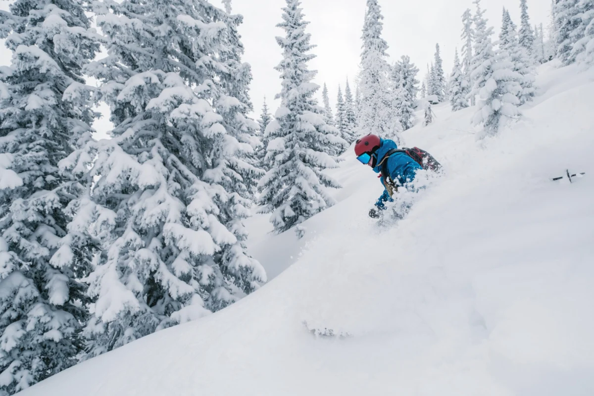
For the dedicated cohort of skiers and snowboarders who refuse to hang up their gear until absolutely necessary, this storm represents an unexpected and thrilling extension of the winter season. Many resorts in the Pacific Northwest typically close by mid-April or early May, making a substantial snowfall event in late April or early May a rare treat. The prospect of fresh powder, even if accompanied by challenging conditions, invigorates the winter sports community, providing a final opportunity to carve turns on untouched snow. This late-season surge could even lead some resorts to consider temporary re-openings or extend their operations for an additional weekend, depending on snow depths and demand.
Those with the flexibility to take a midweek "sick day" on Thursday morning are likely to experience the best conditions. By then, the coldest air will have settled in, converting the dense moisture into higher-quality powder, and the bulk of the storm will be passing. While winds may still be a factor, the promise of fresh, deep snow on a weekday, often accompanied by fewer crowds, presents an irresistible allure for true powder hounds.
Looking Ahead: Post-Storm Conditions and Long-Term Outlook
By Friday, the storm system is expected to fully track eastward, allowing for drier and milder conditions to settle over the Pacific Northwest. This post-storm clearing will be crucial for stabilizing the fresh snowpack. While the intense winds will have sculpted the snow in some areas, the subsequent calmer weather will help preserve the new accumulations, particularly on higher, north-facing terrain. This preservation is excellent news for weekend warriors who might not be able to capitalize on the midweek powder, as they can look forward to soft, spring-like conditions on Saturday and Sunday.
The long-term outlook beyond this immediate storm cycle points towards a gradual return to more typical late-spring weather, with increasing temperatures and sunshine. However, the impact of this significant snowfall will resonate for weeks to come, influencing snowmelt rates, river levels, and the overall hydrological balance of the region. This late-season event serves as a vivid reminder of the dynamic and sometimes unpredictable nature of the Pacific Northwest’s mountain weather, offering both challenges and a final, exhilarating flourish to the winter season.
