

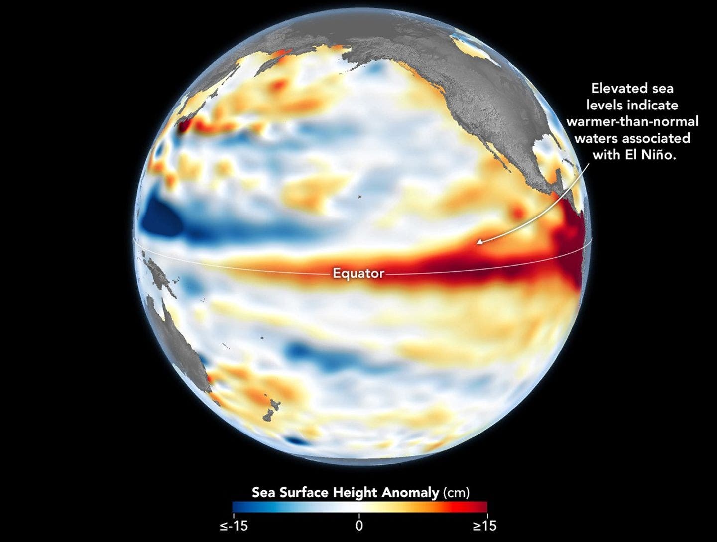
Forecasters have been sounding the alarm for months: the winter of 2026-2027 is shaping up to be dominated by one of the most powerful El Niño events in recorded history. This seismic shift in global weather patterns has left skiers and snowboarders across North America eagerly seeking an answer to a singular question: where will the snow fall, and which resorts will offer the best chance for a powder-filled season? While early predictions offered tentative guidance, the reality is that pinpointing precise snowfall locations remains a complex puzzle, even with the unprecedented strength of the anticipated El Niño.
The National Oceanic and Atmospheric Administration (NOAA) has solidified its confidence in an exceptionally strong El Niño event, projecting its influence to permeate the entire 2026-2027 ski season, from the early autumn months through the spring thaw. However, a surprising nuance has emerged: the sheer magnitude of an El Niño does not directly correlate with a more predictable or amplified snowfall across specific regions. This paradox leaves many eager to plan their winter escapes in a state of informed anticipation, balancing the certainty of a powerful climate driver with the inherent unpredictability of atmospheric responses.
The Unmistakable Signal: A Powerful El Niño is Here
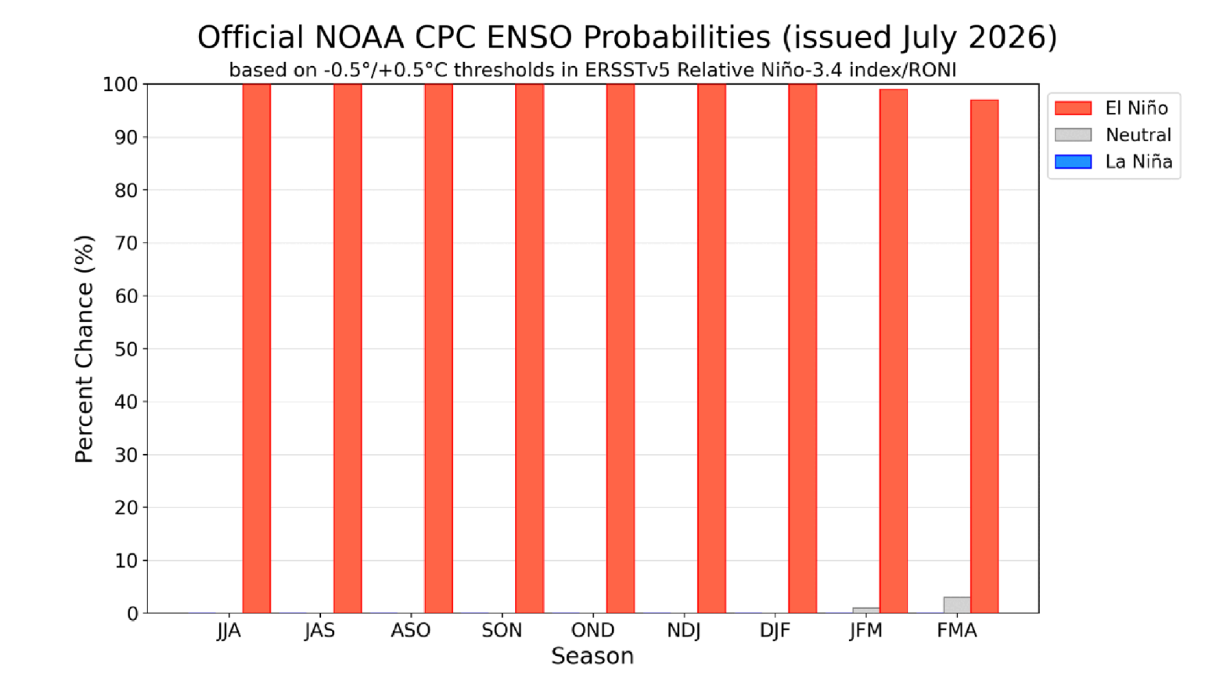
The scientific consensus is increasingly robust regarding the impending El Niño. NOAA’s latest assessments indicate a staggering 97% probability that this significant climate pattern will persist through early spring 2027, ensuring its pervasive impact on winter weather across the Northern Hemisphere. This high level of confidence is a departure from many previous El Niño forecasts, which often carried a greater degree of uncertainty regarding their longevity and intensity.
Furthermore, NOAA estimates an 81% chance that the event will reach "very strong" status during the fall season. The projected peak influence of this El Niño is anticipated between October and December, a critical period that directly precedes and coincides with the early stages of the ski season. While the event is expected to gradually weaken as winter progresses, its strongest atmospheric imprint is likely to be felt around the traditional start of the ski season in late October and November. This timing is particularly noteworthy, as it suggests that the most significant climatic influence may arrive before the peak holiday ski periods, potentially impacting early-season conditions more profoundly than mid-winter storms.
Despite this growing certainty surrounding the El Niño’s presence and strength, the crucial question of its impact on North American snowfall remains a subject of considerable scientific scrutiny and regional variability.
The Paradox of Strength: A Bigger El Niño Doesn’t Guarantee Snowfall Certainty
A common misconception is that a more powerful El Niño automatically translates into a more straightforward and accurate snowfall forecast for ski resorts. However, meteorological experts emphasize that the strength of an El Niño acts more as a "loaded dice" than a direct predictor of outcomes.
"The strength of an El Niño tells you how loaded the dice are," explains Nick Russill, a meteorologist at Snow-Forecast.com. "It doesn’t tell you which way they’ll land."
Russill elaborates that while El Niño events can indeed influence the general odds of wetter or drier conditions across broad geographical areas, they do not dictate the precise track of individual winter storms. The ultimate trajectory of these storms is still governed by the dynamic and often elusive behavior of the jet stream and other complex atmospheric patterns, which remain inherently difficult to forecast with high confidence this far in advance.
This inherent atmospheric variability is reflected in NOAA’s current outlook, which shows no definitive precipitation signal for many of the West’s most popular ski destinations, including Colorado, Utah, and the Tahoe region. The designation of "equal chances" for above-, below-, or near-normal precipitation in these areas does not signify an average winter. Instead, it indicates that current atmospheric models lack a strong consensus or lean towards any particular outcome. A single, persistent storm track, if it materializes favorably, could rapidly transform an uncertain forecast into a banner season for some resorts, while others might experience a disappointing lack of snow. Therefore, while the strength of this El Niño is a significant indicator, it serves as a potential amplifier of existing trends rather than a definitive predictor of snowfall.
Historical Precedents: Lessons from the 2015-2016 El Niño
The temptation to book flights and accommodations based solely on the strength of the current El Niño forecast is understandable, particularly for avid skiers. However, recent historical precedent offers a crucial cautionary tale. The blockbuster El Niño event of the 2015-2016 season, which was widely anticipated to follow a classic pattern of a dry Pacific Northwest and a snowy California, delivered an unexpected outcome. Instead, the Pacific Northwest experienced wetter-than-average conditions, while Southern California, which had been projected to receive drought-busting snow, fell short of expectations.
A subsequent NOAA-supported study shed light on this anomaly. Researchers concluded that the strength of the El Niño itself was not the sole determinant of snowfall patterns. Instead, unpredictable shifts in atmospheric circulation over the northeastern Pacific played a pivotal role in dictating storm tracks, effectively overriding the broader climatic signal provided by the El Niño. This finding underscores a fundamental principle for skiers: El Niño can influence probabilities, but it does not unilaterally control weather outcomes. Even in regions where El Niño typically exerts its strongest influence, such as Southern California, its contribution to annual precipitation was found to be a fraction of the total. This influence diminishes further north, in areas like Tahoe, highlighting the persistent uncertainty that accompanies even the most powerful El Niño events.
Regional Snowfall Outlook: Where the Odds Are Shifting
While the overall winter snowfall remains subject to atmospheric whims, NOAA’s latest outlook does provide some regional distinctions, offering tentative guidance for those planning their ski trips. The current strongest signals point towards increased precipitation in the Southwest, while the northern mountain ranges face potentially greater challenges.
The Early Favorites: Arizona, New Mexico, and Southern Utah
The Southwestern United States is currently presenting the most encouraging forecast for snowfall. NOAA is projecting above-normal precipitation across Arizona and New Mexico, with temperatures expected to remain closer to average by mid-winter. This setup bodes well for ski resorts in these states, including prominent destinations like Taos Ski Valley, Ski Santa Fe, and Arizona Snowbowl, positioning them favorably for a strong start to the season. The higher elevations in these regions are particularly well-suited to capitalize on enhanced moisture.
The Question Marks: Colorado, Northern Utah, and Tahoe
For several of the West’s most beloved ski destinations, including Colorado, northern Utah, and the Tahoe Basin, the forecast remains notably ambiguous. NOAA’s models currently indicate "equal chances" of above-, below-, or near-normal precipitation for these regions. This lack of a clear signal means that a highly favorable or a disappointing winter are equally plausible outcomes. The potential for a spectacular season in these areas hinges on the emergence of a well-timed and persistent storm track, a variable that is currently difficult to predict. Skiers considering these destinations may wish to monitor more localized forecasts as the season approaches.
The Most Risky: Washington, Oregon, Idaho, and Montana
The Pacific Northwest and the northern Rocky Mountain states of Idaho and Montana are exhibiting the clearest warm signal in NOAA’s outlook. This suggests a higher probability of above-normal temperatures and, consequently, below-normal precipitation. For ski resorts in these areas, the primary challenge may not be an outright lack of snow, but rather warmer conditions that could lead to more rain at lower elevations and potentially less consistent snow quality, especially during the shoulder seasons. Elevation will likely be a critical factor in determining snow conditions in these regions, with higher-altitude resorts potentially faring better.
Colorado’s Coin Flip: Elevation and Location are Key
For Colorado, a state synonymous with exceptional skiing, the current outlook presents a scenario of considerable uncertainty. Meteorologist Nick Russill describes the situation as a "50/50 coin flip" for many of the state’s resorts. The absence of a significant precipitation signal, coupled with the expectation of warmer temperatures, elevates the importance of localized factors such as elevation and specific storm trajectories.
Following the most recent advisories, skiers looking to maximize their chances in Colorado are advised to consider destinations in the southern part of the state, which currently show a slightly better propensity for higher-than-average snowfall. Resorts like Telluride, Wolf Creek, and Purgatory, due to their southerly latitudes and varying elevations, may benefit more from the prevailing El Niño patterns. Conversely, planning for Front Range and northern Colorado destinations may require a more cautious approach, with a recommendation to defer bookings until more definitive forecasting information becomes available.
East Coast and Midwest Outlook: Neutral to Challenging Conditions
The influence of this El Niño on Eastern and Midwestern ski areas is projected to be less pronounced compared to the West, offering a more neutral outlook for many. New England resorts are not seeing a clear indication of either a significantly wetter or drier winter. The primary concern for these areas, and indeed much of the East Coast, revolves around temperature. Mild conditions could present challenges for maintaining consistent snow quality, particularly during the early and late periods of the ski season when temperatures are more marginal.
The Great Lakes region faces a slightly more complex scenario. The efficacy of lake-effect snow, a critical factor for many resorts in this area, is dependent on cold air masses sweeping across relatively warm lake waters. An El Niño pattern that favors milder temperatures can disrupt this delicate balance, potentially reducing the frequency and intensity of these localized snow events. Resorts heavily reliant on lake-effect snow may find this winter more challenging as a result.
Planning for the Winter of 2026-2027: Strategic Travel Tips
As skiers and snowboarders navigate the complexities of the 2026-2027 winter forecast, several key takeaways from meteorological experts can inform travel planning:
- Embrace Flexibility: Given the inherent uncertainties, maintaining flexibility in travel plans is paramount. Consider destinations with a stronger current forecast but be prepared to adjust if conditions evolve.
- Monitor Forecasts Closely: The next comprehensive NOAA outlook is scheduled for release on August 13th, and subsequent updates will provide more refined regional predictions. Regularly consulting reliable weather sources, including specialized ski forecasting sites, will be crucial.
- Prioritize Elevation: In regions with uncertain snowfall, particularly the Pacific Northwest and the Rockies, higher elevation resorts are likely to offer more reliable snow conditions due to their greater ability to retain snow and experience colder temperatures.
- Southwest Focus: For those seeking the highest probability of snow, destinations in Arizona, New Mexico, and southern Utah currently present the most promising outlook.
- Colorado Caution: While southern Colorado resorts appear to have a slight edge, the state’s overall forecast remains a coin flip. Southern resorts like Telluride, Wolf Creek, and Purgatory are currently favored over northern and Front Range locations.
- East Coast Temperature Watch: For East Coast skiers, monitoring temperature forecasts will be as important as precipitation predictions, as mild conditions could significantly impact snow quality and resort operations.
- Midwest Lake-Effect Dependence: Resorts in the Great Lakes region relying on lake-effect snow should pay close attention to forecasts for cold air outbreaks.
Ultimately, while the impending super El Niño provides a strong underlying climate signal, the intricate dance of atmospheric patterns will dictate the precise snowfall across North America. Skiers who stay informed and adaptable are best positioned to capitalize on whatever winter 2026-2027 may bring.
