


As the leaves begin to turn and the crisp air signals the approach of winter, skiers across North America are eagerly scanning the horizon for a promising snow season. This year, the conversation is dominated by the specter of one of the strongest El Niño events in recorded history. Forecasters have been sounding the alarm since spring, but the burning question for powder enthusiasts remains: where will the snow fall? While the scientific consensus on the strength of the impending El Niño is remarkably high, its impact on specific ski destinations is far from certain, presenting a complex puzzle for those hoping to book their winter getaways.
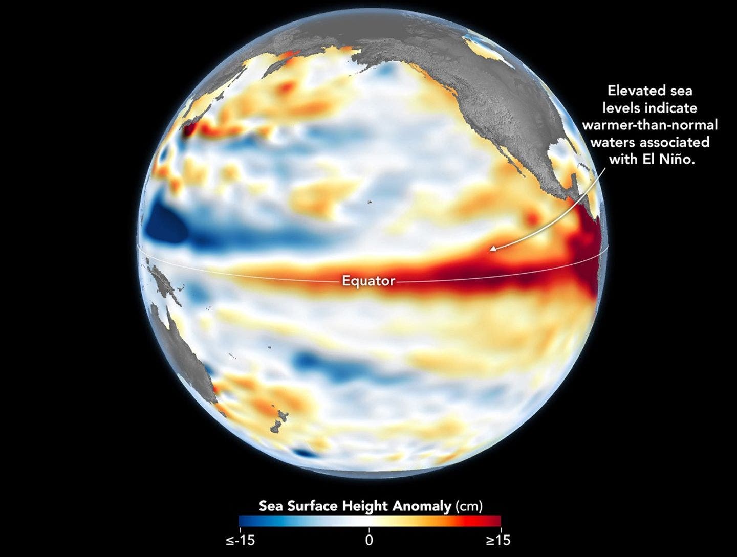
The National Oceanic and Atmospheric Administration (NOAA) has become increasingly confident that an exceptionally strong El Niño will influence weather patterns across North America throughout the entire 2026-2027 ski season, from early fall through early spring. However, the sheer power of this climate phenomenon does not translate into a crystal-clear map of where the deepest powder will accumulate. This nuanced reality underscores the inherent unpredictability of atmospheric science, even when faced with robust global climate signals.
The Unfolding El Niño Phenomenon
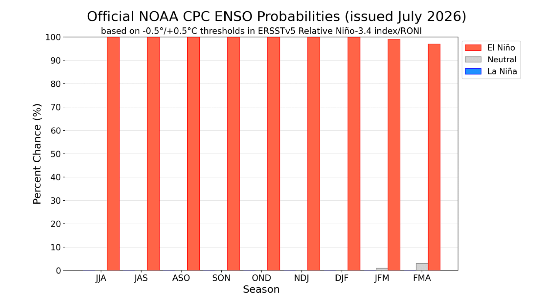
The scientific community’s certainty surrounding the development of a potent El Niño event is at an all-time high. NOAA’s latest projections indicate a staggering 97 percent probability that this El Niño pattern will persist through early spring 2027, ensuring its influence will be felt across the entire ski season. This sustained presence is a critical factor, as it suggests a prolonged period of altered atmospheric conditions that could significantly impact winter weather.
Furthermore, NOAA’s data suggests an 81 percent likelihood that the El Niño will reach "very strong" status during the fall months. The climate signal is anticipated to peak between October and December, precisely when many ski resorts begin to open their doors. This early-season peak is noteworthy, as it means the most intense phase of the El Niño may occur before the traditional mid-winter months of January and February, which often see the heaviest snowfall. While this timing could offer an early boost to the season, it also adds another layer of complexity to predicting mid-winter conditions.
This burgeoning confidence in the El Niño event itself, however, does not automatically translate into a more precise forecast for snowfall. The intricate dance of weather systems over North America remains susceptible to a myriad of factors that can override or subtly alter the broad strokes painted by El Niño.
The Strength-Snowfall Disconnect
A common assumption is that a more powerful El Niño event would inherently lead to more predictable and potentially bountiful snowfall across ski destinations. However, meteorologists caution that this is a misleading simplification. Nick Russill, a meteorologist at Snow-Forecast.com, likens the strength of an El Niño to "how loaded the dice are," emphasizing that "it doesn’t tell you which way they’ll land."
While El Niño events are known to influence regional precipitation patterns, generally favoring wetter conditions in some areas and drier conditions in others, they do not dictate the precise track of winter storms. This crucial detail remains largely at the mercy of the atmosphere’s complex dynamics, particularly the behavior of the jet stream and other transient weather patterns that are notoriously difficult to forecast with high accuracy this far in advance.
Consequently, NOAA’s current outlook offers no definitive precipitation signal for many of the West’s most popular ski regions, including Colorado, Utah, and the Tahoe basin. The phrase "equal chances" in these forecasts does not imply an average winter; rather, it signifies that current models lack a strong predictive lean in either direction. A single, persistent storm track, if it materializes, could dramatically alter these uncertain projections, leading to either an exceptional season or a disappointing one. In essence, while this year’s exceptionally strong El Niño is a significant meteorological clue, it serves as a loading of the dice rather than a predetermined outcome.
Historical Precedents: A Cautionary Tale
For skiers contemplating booking early based solely on the El Niño forecast, recent history provides a stark reminder to exercise caution. The lead-up to the blockbuster 2015-2016 El Niño season saw widespread predictions of a classic pattern: a dry Pacific Northwest and a storm-laden California. The reality, however, was the opposite. The Pacific Northwest experienced a wetter-than-forecast winter, while Southern California, which had eagerly anticipated drought-breaking snowfall, fell short of expectations.
Investigations following that season, including a NOAA-supported study, revealed that the strength of the El Niño was not the primary determinant of the observed weather patterns. Instead, unpredictable shifts in atmospheric circulation over the northeastern Pacific played a more significant role in dictating storm tracks, ultimately overwhelming the broader climate signal provided by El Niño.
This historical anomaly underscores a critical takeaway for skiers: while El Niño can influence the odds, it does not unilaterally control the outcome. Even in regions where El Niño typically exerts its strongest influence, such as Southern California, the phenomenon accounts for only a fraction of the winter’s total precipitation. In areas further north, like Tahoe, this relationship weakens considerably. Therefore, despite the compelling headlines surrounding the current El Niño, a degree of uncertainty is inherent in this winter’s snow forecast.
Pinpointing Potential Snow Havens
Despite the overall uncertainty, NOAA’s latest outlook does offer some regional distinctions that can help skiers refine their travel plans. Currently, the strongest precipitation signal appears to favor the Southwestern United States, while the northern mountain ranges face potentially greater challenges.
The Early Favorites: Arizona, New Mexico, and Southern Utah
The Southwest is emerging as the region with the most promising setup for the upcoming ski season. NOAA’s projections indicate above-normal precipitation across Arizona and New Mexico, coupled with temperatures expected to trend closer to normal by midwinter. This confluence of factors positions resorts such as Taos Ski Valley, Ski Santa Fe, and Arizona Snowbowl favorably for receiving ample snowfall. These areas are often less reliant on the whims of the jet stream’s precise path compared to more northerly destinations.
The Question Marks: Colorado, Northern Utah, and Tahoe
For many of the West’s most iconic ski destinations, the forecast remains decidedly ambiguous. NOAA currently predicts "equal chances" of above-, below-, or near-normal precipitation across Colorado, Utah, and the Tahoe region. This does not imply an average winter; rather, it suggests that current meteorological models lack a sufficiently strong signal to favor one outcome over another. A well-timed series of storms could still lead to an exceptional season in these areas, but conversely, they could also experience a deficit of snowfall. Skiers with flexibility may wish to monitor these regions closely as the season progresses.
The Most Risky: Washington, Oregon, Idaho, and Montana
The Pacific Northwest and the northern Rockies present the clearest warm signal in NOAA’s outlook, with projections favoring above-normal temperatures and below-normal precipitation throughout the winter. For resorts in these areas, the primary challenge may not be a complete absence of snow, but rather warmer conditions that could lead to wetter, heavier snow or rain at lower elevations. This could impact snow quality and consistency, particularly on beginner and intermediate terrain. For skiers considering these regions, a focus on higher-elevation resorts may be prudent.
The overarching message for skiers is clear: the specific location of their chosen destination may prove to be as critical as the timing of their visit this winter. Elevation will undoubtedly play a more significant role in snow accumulation than in years with more definitive precipitation forecasts.
Colorado’s Coin-Flip Winter
The state of Colorado, a perennial favorite for skiers, faces a particularly uncertain outlook. According to Russill, the forecast for Colorado’s resorts is essentially a "50/50" proposition at this juncture. The absence of a significant precipitation signal, coupled with the expectation of warmer temperatures, elevates the importance of factors such as elevation and the precise trajectory of individual storm systems. A single, well-placed storm could dramatically alter the fortunes of a particular resort or region within the state.
Based on the currently available guidance, skiers targeting Colorado might find greater success by focusing on the state’s southern ski areas, which tend to benefit more directly from southerly storm tracks that can be influenced by El Niño. Destinations like Telluride, Wolf Creek, and Purgatory, located in the southwestern part of the state, are considered better bets. Conversely, planning for resorts in the Front Range and northern regions of Colorado might be best postponed until more definitive information becomes available.
East Coast and Midwest Outlook
The El Niño forecast offers a more neutral, albeit not entirely rosy, outlook for most East Coast ski areas. Unlike the West, where the El Niño signal is more pronounced, the forecast for New England remains relatively balanced. There is no clear indication of a consistent pattern of wetter-than-normal storms, nor is there a strong signal pointing towards a dry winter.
However, a primary concern for the East Coast is the potential for warmer temperatures. Mild conditions could hinder resorts’ ability to maintain consistent snow coverage, particularly during the marginal periods at the beginning and end of the ski season. This could lead to more variable conditions and a greater reliance on artificial snowmaking.
The Great Lakes region faces a somewhat more challenging scenario. Lake-effect snow, a significant contributor to winter totals in this area, is dependent on cold air masses sweeping across relatively warm lake waters. An El Niño pattern that favors milder temperatures can disrupt this delicate balance, potentially reducing the frequency and intensity of lake-effect storms. Resorts that heavily rely on these localized snow events may find this winter to be more limiting.
Navigating Winter Travel: Strategic Planning Tips
As skiers grapple with the nuanced predictions for the 2026-2027 season, strategic planning becomes paramount. Based on the insights from Snow-Forecast.com and NOAA, several actionable takeaways can guide travel decisions:
- Prioritize Higher Elevations: In regions with uncertain precipitation forecasts, particularly the Pacific Northwest and northern Rockies, resorts at higher elevations are generally more likely to retain snow and experience colder temperatures conducive to good skiing conditions.
- Favor the Southwest: The current NOAA outlook suggests that Arizona, New Mexico, and southern Utah offer the most promising precipitation signals. For those seeking the highest probability of snow, these states should be at the top of the consideration list.
- Monitor Colorado Closely: While the outlook for Colorado is a coin flip, southern resorts like Telluride and Purgatory may have an edge. However, given the volatility, skiers should stay tuned for more localized updates as the season approaches.
- Understand the Nuances of "Equal Chances": This forecast term does not imply average conditions. It signifies a lack of a strong predictive signal and highlights the potential for highly variable outcomes. Flexibility and a willingness to adapt plans based on emerging weather patterns will be key.
- Be Prepared for Warmer Conditions: In the East and parts of the Midwest, warmer temperatures could be a limiting factor. Skiers should research resorts’ snowmaking capabilities and consider the potential for variable conditions.
- Stay Informed: The next NOAA outlook is scheduled for release on August 13th, and further insights will be provided as new data becomes available. Regularly checking reliable meteorological sources and ski-specific forecasts is crucial for making informed decisions.
In conclusion, while the prospect of a super El Niño event generates considerable excitement and anticipation, it serves as a complex variable in the equation of winter snowfall. The scientific community is confident about the phenomenon’s strength and duration, but the precise impact on ski resorts across North America remains a captivating mystery. For skiers, this season promises a blend of opportunity and uncertainty, where informed planning and a touch of adaptability will likely be the keys to unlocking a memorable winter on the slopes.
