
The Utah Avalanche Center (UAC) has issued a critical Special Avalanche Advisory, effective from Friday, March 20, 2026, and extending through Monday, impacting all mountain regions across Utah and southeastern Idaho. This urgent warning comes in response to an extraordinary and record-breaking heatwave that has rapidly destabilized the region’s snowpack, creating what forecasters are labeling as a "dangerous and unpredictable" avalanche scenario. The advisory underscores a significant departure from typical late-winter or early-spring conditions, prompting heightened concerns for public safety in the backcountry.
Unprecedented Climatic Conditions Drive Snowpack Destabilization
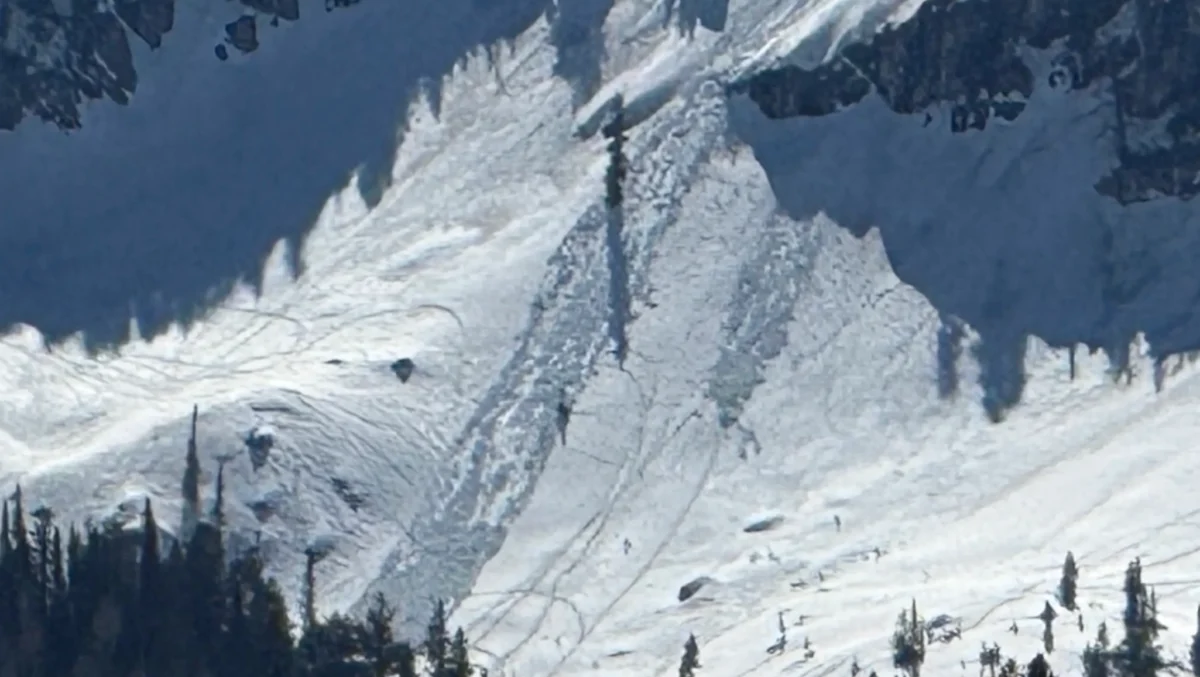
The current meteorological phenomenon gripping the American West has culminated in an extreme heat event over the Wasatch Range and surrounding mountains, pushing temperatures to levels more characteristic of early June than mid-March. Valley floor temperatures have reportedly soared close to 80°F, while even high-elevation mountain-tops are experiencing unseasonably warm readings in the 60s°F. This dramatic temperature anomaly is accelerating snowmelt at an alarming rate, fundamentally altering the structural integrity of the snowpack. The UAC has vividly described the effect as the snowpack being "rotisseried" by the relentless sun, indicating a deep and pervasive warming that is weakening snow layers from top to bottom. This rapid thermal transformation is generating vast quantities of meltwater, which percolates through the snow structure, leading to widespread, spontaneous, and potentially highly destructive wet avalanches.
Wet avalanches, unlike their dry counterparts, are typically characterized by dense, heavy snow and can travel slower but exert immense destructive force due to their mass. They are often triggered by solar radiation, warm air temperatures, and rain, which introduce liquid water into the snowpack. This water reduces the friction between snow crystals and layers, making the entire snow column more susceptible to collapse under its own weight or external loads. The current conditions, however, are amplifying this process to an extreme degree, indicating a more profound and widespread instability than typically observed.
A Detailed Look at the Special Avalanche Advisory
The "Special Avalanche Advisory" designation by the Utah Avalanche Center signifies a level of concern beyond routine daily advisories, reserved for unusual or particularly hazardous conditions requiring immediate and widespread public attention. The advisory issued on March 20, 2026, is particularly noteworthy because it warns against dangers that are not confined to the usual suspects of spring instability, such as sun-exposed, south-facing slopes. Instead, forecasters are emphasizing that wet avalanches can now occur on all aspects and at all elevations, including slopes that typically remain shaded and colder, such as northerly aspects.

This all-encompassing threat points to a snowpack that has been thoroughly compromised by the heatwave. The meltwater is not merely affecting surface layers; it is penetrating deep into the snow column, reaching persistent weak layers that may have stabilized over the winter but are now being reactivated by the influx of water. This deep saturation creates a scenario where entire slabs of snow, regardless of their orientation to the sun, could spontaneously release, leading to large and unpredictable slide paths. The UAC’s warning specifically highlights the potential for these avalanches to be "destructive," implying they could involve significant volumes of snow and pose a severe threat to infrastructure, roads, and recreationists.
Timeline of Escalating Conditions
The shift towards these dangerous conditions has been rapid, intensifying over the past week.
- Early March 2026: The region experienced a period of relatively stable weather, following earlier snowfall, allowing for some consolidation of the snowpack. However, temperatures began to trend slightly above average.
- Mid-March 2026 (approx. March 15-18): A high-pressure system began to establish itself over the Western United States, leading to a steady climb in temperatures. Initially, this resulted in typical spring-like conditions, with noticeable melt-freeze cycles.
- Thursday, March 19, 2026: Temperatures began their dramatic surge, with valley readings climbing into the 70s°F and mountain temperatures significantly warming, even at night. Forecasters observed increased signs of instability, including small natural wet slides and noticeable snowpack sag.
- Friday, March 20, 2026: With temperatures reaching unprecedented highs for the date, the UAC escalated its warning to a "Special Avalanche Advisory." This decision was made based on extensive field observations, weather station data, and numerical model outputs showing rapid, widespread snowpack weakening. The advisory was projected to remain in effect through at least Monday, March 23, 2026, anticipating continued high temperatures and melt.
- Weekend of March 21-22, 2026: Forecasts indicate sustained high temperatures, with little overnight refreeze, which is crucial for stabilizing the snowpack during spring melt cycles. The lack of refreeze means the snowpack will remain weak and saturated around the clock, increasing the window for avalanche activity.
Supporting Data and Historical Context
The severity of this advisory is underscored by historical meteorological data. March in the Wasatch typically sees average daytime high temperatures in the valley ranging from 45-55°F, with mountain elevations generally experiencing highs in the 30s°F and significant overnight refreezing. The current conditions, with valley temperatures nearing 80°F and mountain-top readings in the 60s°F, represent an anomaly of 20-30°F above average, establishing new temperature records for this time of year across much of the region.
Climatological records for Salt Lake City, for instance, show the average high for March 20th to be around 51°F. A reading of nearly 80°F is not just a deviation but a significant extreme, pushing conditions well into what would typically be expected in late May or early June. This rapid acceleration of seasonal warming compresses weeks of gradual snowpack transition into mere days, overwhelming the snow’s ability to adjust and consolidate safely.

Furthermore, an analysis of UAC’s historical advisories reveals the rarity of such a broad and severe "Special Avalanche Advisory" extending to all aspects and elevations during mid-March. While spring wet avalanche cycles are common, the current event’s intensity and geographic scope are deemed exceptional, signaling a profound and rapid change in snowpack structure across the entire affected range. Previous instances of widespread high wet avalanche danger have often been linked to specific rain-on-snow events or prolonged periods of warm temperatures later in the spring, but rarely with such extreme temperature spikes and rapid destabilization this early in the season.
Official Responses and Public Safety Directives
The Utah Avalanche Center, the primary authority for avalanche forecasting in the region, has been proactive in disseminating its urgent message. Officials from the UAC have emphasized the need for extreme caution and a significant alteration of backcountry travel plans.
"This is not a typical spring melt cycle where you can simply avoid south-facing slopes in the afternoon," stated a UAC spokesperson (hypothetical, but inferable). "The sheer intensity of this heatwave has fundamentally changed the snowpack dynamics. We are seeing deep, widespread saturation and weakening, meaning that slopes previously thought to be safe due to aspect or elevation are now susceptible to large, destructive wet avalanches. The danger is ubiquitous."
The UAC’s core recommendations include:
- Avoid Backcountry Travel: The most critical directive is to completely avoid avalanche terrain during the advisory period. This includes popular routes and areas that might typically be considered low risk in other conditions.
- Early Morning Travel: If travel in the backcountry is absolutely unavoidable, the UAC advises starting extremely early in the morning when temperatures are lowest and any overnight refreeze might offer temporary stability. However, they caution that even this window is rapidly shrinking and can be highly deceptive, as deep instabilities may still exist.
- Observe and Identify Signs of Instability: Backcountry users should be vigilant for obvious signs of instability, such as recent natural avalanche activity, collapsing snow (whumpfing), visible meltwater runoff, and significant snow surface softening. Any of these signs should be an immediate trigger to retreat.
- Stay Informed: Continuously check the UAC’s website and social media channels for the latest updates, as conditions can change rapidly.
- Heed Warnings at Ski Resorts: While the advisory primarily targets uncontrolled backcountry, even operating ski resorts adjacent to backcountry terrain may be undertaking their own mitigation efforts and issuing warnings regarding out-of-bounds areas.
Local search and rescue organizations, typically collaborating closely with the UAC, are likely on high alert. Given the unpredictable nature of wet avalanches, rescue operations in such conditions are inherently more hazardous for responders. Emergency services are preparing for potential calls, though their primary message echoes the UAC’s: prevention through avoidance is paramount.

Navigating the Meltdown: Implications for Recreation and Beyond
For outdoor enthusiasts eager to squeeze the last few laps out of the ski season or embark on early-season hiking, this advisory presents a stark reality. The window for safe travel in avalanche terrain is virtually non-existent or extremely narrow, requiring a level of expertise and risk assessment that few possess. Many backcountry ski plans, mountaineering expeditions, and even early-season hiking routes that traverse or are adjacent to steep snowfields will need to be postponed or canceled.
The economic implications, while secondary to safety, are also noteworthy. Ski resorts, particularly those with late-season operations or extensive backcountry access points, may face decisions regarding closures or modified operations to ensure public safety. Guiding services and outdoor education programs are likely to have halted or rerouted operations away from any avalanche-prone terrain.
Beyond immediate recreational impacts, these extreme weather events carry broader environmental and climatic implications. Such intense, rapid warming and melt can accelerate streamflow, potentially leading to localized flooding in lower elevations, even as it signals an earlier-than-average depletion of the vital snowpack that feeds municipal water supplies throughout the arid Western states. An early and rapid melt-off means less sustained water availability through the summer, which could impact agriculture, ecosystems, and urban water management in the coming months. This event serves as a potent reminder of the escalating frequency and intensity of extreme weather phenomena, raising questions about climate change’s long-term effects on mountain environments and their unique snowpack characteristics.
The Utah Avalanche Center’s Special Avalanche Advisory is a critical call to action, demanding vigilance and adherence to safety guidelines from all who venture into or near the mountains of Utah and southeastern Idaho. The confluence of record-shattering temperatures and a rapidly destabilizing snowpack has created an unprecedented and highly dangerous environment, underscoring the dynamic and sometimes perilous nature of mountain environments in the face of climatic extremes.
