

The 2025-2026 snow season across the Western United States has concluded as a historic anomaly, characterized by record-breaking thermal interference that disrupted traditional hydrological cycles and decimated the regional winter sports economy. While precipitation levels across several states remained within a statistically normal range, an unprecedented lack of sustained cold temperatures transformed what could have been a robust winter into a "hot mess" of rain-on-snow events and premature melting. This atmospheric trend has left water managers, agricultural stakeholders, and environmental scientists grappling with the implications of a drastically shortened snow storage window.
According to data synthesized by Dr. David Hill, a professor at Oregon State University and National Geographic Explorer, the season was defined not by a lack of moisture, but by a persistent "thermal nightmare." As the region transitions into the summer months, the focus has shifted from the disappointment of shortened ski seasons to the more pressing concern of water security for the millions of residents and thousands of acres of farmland that rely on the mountain snowpack as a natural reservoir.
A Season of Moving Goalposts: The 2025-2026 Chronology
The 2025-2026 winter season began with cautious optimism as early autumn storms suggested a return to healthy precipitation levels. However, as the calendar turned to December, the reality of a warming climate became starkly apparent.
The December Thermal Anomaly
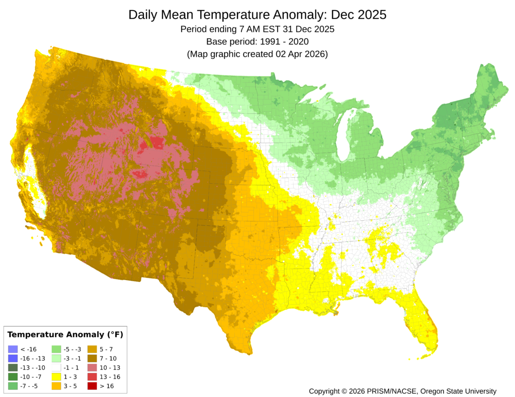
December 2025 is now recorded as one of the most detrimental months for snow accumulation in the history of the Western U.S. While the Northeast and Upper Midwest experienced temperatures up to 5 degrees Fahrenheit below average, the West saw the opposite extreme. Much of the region experienced temperature anomalies ranging from 5 to 15 degrees Fahrenheit above long-term averages. This thermal surge prevented the establishment of a base layer at lower and mid-elevation ski resorts and caused existing high-altitude snow to undergo premature metamorphosis.
The Shifting Operational Window
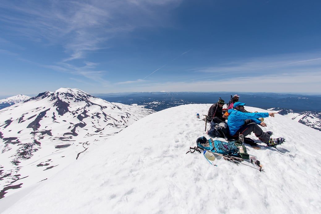
For ski resort operators and backcountry enthusiasts, the season was a series of delayed expectations. Traditionally, the New Year’s holiday serves as the primary revenue driver and the benchmark for "full operation." When the snow failed to materialize by January 1, industry analysts looked toward Martin Luther King Jr. Weekend. When that window also passed with "low tide" conditions, hopes were pinned on Presidents’ Day. Ultimately, many regions did not see significant, "skiable" accumulation until Spring Break—a period when the sun angle is typically too high to maintain a durable snowpack.

Premature Melt-Out
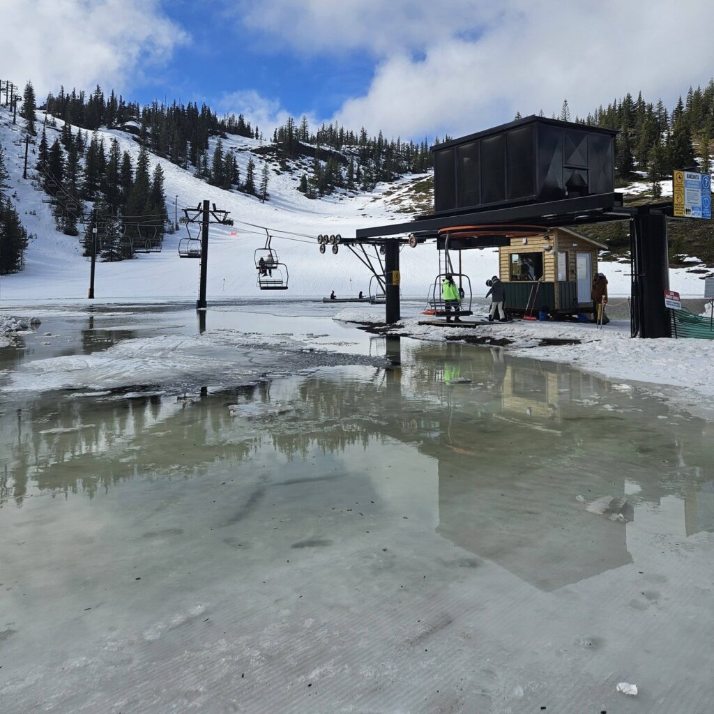
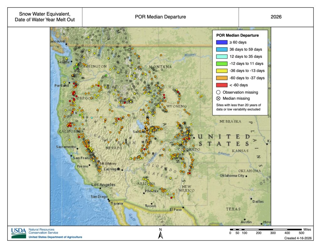
By mid-March, the situation transitioned from a lack of accumulation to an accelerated loss of existing resources. At the Hoodoo Ski Area on Oregon’s Santiam Pass, an unscheduled "pond skim"—an event usually reserved for the final day of the season in late April or May—occurred naturally due to rapid melting. By mid-April, many observation stations reported that the snow had entirely vanished. These "snow-off" dates were recorded not just days or weeks early, but in some instances, more than two months ahead of the long-term average.
Regional Precipitation vs. Snow Accumulation
A critical distinction in the 2025-2026 data is the divergence between total precipitation and Snow Water Equivalent (SWE). The "recipe" for a healthy winter requires both moisture and cold; this year, the West only received the former.
- The Wet Regions: Northwest Wyoming, Montana, Idaho, and Washington experienced a "wet" year, with precipitation levels trending slightly above the historical average. However, because temperatures remained high, much of this moisture fell as rain or "wet snow" that melted quickly, failing to contribute to a sustained seasonal snowpack.
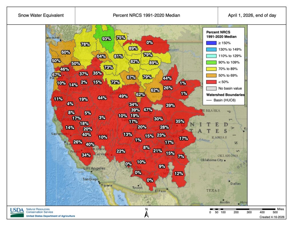
- The Dry Regions: Oregon, Utah, and Colorado ran slightly below average in terms of total moisture. Combined with the high temperatures, these states saw some of the lowest April 1 SWE values in the past 45 years.
- The April 1 Benchmark: Historically, April 1 is used as the primary benchmark for peak snowpack in the Western U.S. In 2025, April 1 values across a majority of the Natural Resources Conservation Service (NRCS) observation stations were a tiny fraction of the average, signaling a catastrophic failure of the natural storage system.
The Global Context: Water Scarcity and the "Sphere" Analogy
To understand the gravity of a failing snowpack, scientists often look at the broader scale of Earth’s water resources. While the Earth is often called the "Blue Planet," the amount of accessible freshwater is remarkably small. If all the water on Earth were gathered into a single sphere, its diameter would be only 40% of the moon’s diameter.
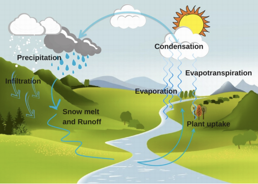
Furthermore, the vast majority of that water is saline or trapped in deep subterranean aquifers and polar ice caps. Less than 0.01% of Earth’s total water is available to support the daily needs of the human population. In the Western United States, the management of this fraction of a percent relies heavily on the timing of the hydrologic cycle—the movement of water from the atmosphere to the land and eventually back to the sea.
The Role of Snow as a Natural Reservoir
The primary challenge in water management is the mismatch between supply and demand. In the West, the majority of precipitation falls during the winter, while the peak demand for agriculture and municipal use occurs during the dry summer months. To bridge this gap, the United States has built an extensive network of infrastructure, including the Hoover Dam and Lake Mead.
However, the "superpower" of the Western water system is the seasonal snowpack. The snowpack acts as a massive, distributed reservoir that holds water in solid form throughout the winter and releases it slowly during the late spring and early summer.
The Scale of Snow Storage
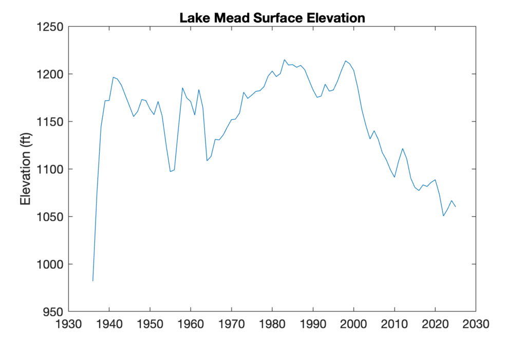
By scientific estimates, the volume of water stored in the contiguous United States’ snowpack at its peak is approximately five times the storage capacity of Lake Mead. Unlike man-made reservoirs, which can disrupt fish passage and sediment flow, the snow reservoir is "low-impact" and widely distributed. It provides a steady flow of cold water into streams, which is essential for the survival of trout, salmon, and other aquatic species that cannot tolerate the higher temperatures of rain-dominated runoff.
The Lake Mead Crisis
The failure of the 2025-2026 snow season exacerbates an existing crisis in the Colorado River Basin. Years of consecutive dry conditions and warm winters have led to steadily declining elevations in Lake Mead. As the reservoir levels drop toward "dead pool" status, the conversation among the seven states that share the basin has turned from cooperation to urgent litigation over water allocations. The lack of a robust snowpack this year removes the "insurance policy" that these states rely on to refill the reservoir system.
Economic and Environmental Implications
The lack of winter cold has immediate and secondary impacts that ripple through the regional economy.
- The Outdoor Recreation Industry: Ski resorts are the economic engines of many rural mountain communities. The 2025-2026 season saw a "start-stop" operational cycle that resulted in significant revenue losses for hotels, restaurants, and equipment retailers.
- Agricultural Vulnerability: Farmers in the Central Valley of California and the Yakima Valley in Washington rely on "junior" water rights that are often curtailed when snowmelt runoff is insufficient. The early melt-out dates of 2026 suggest that irrigation supplies may be exhausted by mid-summer, potentially leading to crop failures or the fallowing of fields.
- Wildfire Risk: A primary predictor of severe wildfire seasons is the timing of snowmelt. When the snow vanishes months early, the forest floor and understory vegetation dry out sooner, extending the "burn window" and increasing the likelihood of high-intensity fires in the late summer and autumn.
Analysis: The Long-Term Trend of Diminishing Winters
While interannual variability—often described as "boom or bust" cycles—is a natural feature of Western weather, the 2025-2026 season aligns with a disturbing long-term trend. Data from SNOTEL (Snow Telemetry) sites, such as the Hogg Pass site in Oregon, show that annual maximum SWE is trending downward over several decades.
The "glass half full" perspective offered by some meteorologists suggests that a lean year is often followed by a record-breaking one. However, climatologists warn that the "baseline" is shifting. As global temperatures rise, the "freezing level" in the atmosphere moves to higher elevations. This means that even in years with high precipitation, a larger percentage of the mountains will receive rain instead of snow, and the "natural reservoir" will continue to shrink.
The 2025-2026 season serves as a stark reminder that the Western United States’ water infrastructure and economy are built on the assumption of a cold winter. When that cold fails to arrive, the entire system—from the ski lift to the irrigation canal—is thrown into jeopardy. As the region prepares for a potentially parched summer, the focus remains on better understanding these "hot mess" winters and developing more resilient strategies for a future where snow is no longer a guarantee.
